This page is intended as a general introduction to the use and development of various technologies used in archaeological and geospatial research. Here you will find information on Global Positioning Systems (GPS) and survey technology; Geographic Information Systems (GIS) and mapping; database technologies; 3D long-range and short-range scanning of architecture and artifacts; satellite and aerial photography and photogrammetry; and much more.
If you have any questions or comments about these archaeological and geospatial technologies, please send an email to the website administrator on the Contact Puget Sound page.
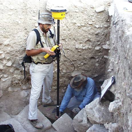
GPS
GPS or Global Positioning System, is a based on a Global Navigation Satellite System (GNSS). It enables the user to configure location, time, speed and direction, all at once, by receiving and transmitting data with Earth orbit satellites by using microwave signals. GPS has filled a number of applications, including in the military field, where GPS is not limited to general navigation, missile projection guidance, in the creation of maps, and reconnaissance. More standard applications of GPS in every day life includes navigation and location systems in planes, automobiles, boats and now even cell phones, tracking devices for hikers or other outdoor enthusiasts, surveying tools for construction sites, and for mapping and building GIS applications. Now, GPS is also being used to survey archaeology excavation sites as well, allowing archaeologists to reconstruct their site in electronic form, aiding making a grid for the site, and managing the overall organization process that is necessary to ensure a smooth excavation process. In addition, GPS on site also allows one to record the exact location that a artifact was found, or the exact length and spatial orientation of some other ancient landmark.
GIS
GIS or Geographical Information Systems, enable one to collect, store, study and manage spatially related information and data as it applies to the earth. In other words, it allows the used to add “layers” to a map. Common applications of this geographically-referenced data base include many of the capabilities seen on Google Earth. Google Earth allows the user to view an area, be it a country or a city block, and select different options to highlight on the map. For example, if someone wanted to see all the restaurants within a five mile radius of their house, all they would have to do was select “restaurants,” and those restaurants would be highlighted on the map. Taking this tool to the field, the same things apply. If one was exploring a map of Khirbet Cana, for example, and wanted to see where all the walls of one time period were, they would select that landmark to highlight, and that’s what would be emphasized on the map. GPS data is gathered and installed to this GIS applications, until one has a detailed, layer by layer description of the site in question, be it a city block in the middle of New York, or an excavation site in Israel.
Summary
The benefits of using GPS & GIS: It allows for more accurate data collection, building complex, layered maps that are useful in data analysis as well as contributing to a growing database centered around GPS and GIS related technology.
Applying GPS and GIS in the field: It allows the archaeologist to obtain more detailed and accurate data that will be available for future generations, and help paint the “large picture.” The use of these geospatial technologies, in addition to others such as GPR or ground-penetrating radar, has sped up the excavation process, allowing archaeologists to get a pretty good idea of what’s going on below the surface before ever lifting a shovel.
Moving archaeology from the world of dirt and time-consuming excavations to the virtual world of the Internet.
- Doug Edwards,
Geo Info Systems, March 2000